what we do
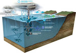
Our main goal is to accurately predict the fate of hydrocarbons (oil) released into the environment, thereby guiding risk management and response efforts to minimize damage to human health, the economy and the environment. This goal will be achieved through: (i) Interconnection of a number of state-of-the-art hydrodynamic models across a vast range of spatial and temporal scales of motions caused by different physical processes; (ii) A dedicated set of in-situ and laboratory experiments designed for model evaluation and parameterization; (iii) Uncertainty analysis to assess model performance and solution space.
Ocean and laboratory experiments
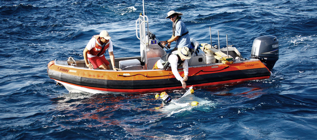
The Grand Lagrangian Deployment (GLAD) is the largest upper ocean dispersion experiment carried out in oceanography to date. Made possible by the extensive collaborative structure encouraged by the Gulf of Mexico Research Initiative (GoMRI), the GLAD experiment involved the deployment of some 317 drifting instruments into the Gulf of Mexico, near the Deepwater Horizon region. The experiment was completed in 10 days and due to its success, a total of 5.5 million data points were collected over a six-month period. An interesting aspect of this study is the unique data set that was created by the passage of Hurricane Isaac over the dispersed GLAD array. The data collected during GLAD is of such value that a specially designed chamber has been installed in the ASIST laboratory to enable quantification of the disruption of the air-oil-water boundary under varying wind and wave regimes. This facility will be used to validate numerical simulations of these multi-phase flows.
Ocean modeling
The Naval Research Laboratory (NRL) contributed to the GLAD experiment by carrying out 72-hour forecasts, using 1-3km Navy Coastal Ocean Models (NCOM) and Hybrid Coordinate Ocean Models (HYCOM) with up to 30 ensembles. The GLAD period has been rerun multiple times in order to analyze and reduce prediction errors. While assimilation methods of drifter positions are being developed by NRL, the deficiency of submesoscale dispersion in NRL models is recognized and steps will be taken to address this issue. High-resolution coastal modeling was conducted during the Hurricane Isaac period and predictions of storm surge were quantified. High-resolution simulations of the near-field plume, as well as multi-phase modeling near the air-sea interface are well in progress.
Transport analysis
Lagrangian Coherent Structures (LCS) are used in two major ways:
LCS as a model performance metric: LCS are the skeletons of patterns formed by passive tracers. Hence, when information on such patterns is available, models can be calibrated in such a way that the LCS they sustain are correctly located relative to these patterns. Studies were carried out by calibrating NCOM simulations using assimilation schemes, based on the ocean color image on 12 July 2012.
LCS as a prediction tool: LCS can sustain highly attracting cores which enable forecasting changes in the shape of a passive tracer pattern by indicating directions of sustained stretching. LCS cores extracted from altimetry-derived velocities were used to anticipate the pathways taken by GLAD drifters five days in advance.
Coupled atmosphere-wave-ocean modeling
Coupled model forecasts ran for a three-month period, starting in June 2012 to cover the GLAD drifters and Hurricane Isaac. Some of the GLAD data (surface winds, SST and sea level pressure) are being used in order to investigate the behavior of the cold wake left over from Isaac as well as the relative influences of winds and storm surge on transport.
Uncertainty analysis
Developed efficient uncertainty quantification schemes for propagating uncertainties from inputs to predictions; established superior performance of sparse adaptive sampling schemes using massive databases of high-resolution OGCM; demonstrated the implementation of UQ schemes to assess the sensitivity of quantities of interest to specific uncertainties; demonstrated the suitability of model surrogates obtained using a modest number of realizations for the purpose of assessing information gains from specific measurements, parameter inference, inverse analysis, planning of field observations, and decision support, e.g. Bayesian inference of key wind drag parameterization using ITOP data; applying Polynomial Chaos & Bayesian inference to evaluate posterior distribution of bottom drag coefficient using DUCK experiment; development of a displacement data assimilation to preserve important dynamical features that might be washed in an ensemble based system. The application is for tracking oil slicks effectively while enforcing basic conservation laws.
Major Findings
Our main finding from GLAD is that oceanic submesoscales affect surface transport, which means that (a) observations are needed in the scale ranges of 10 m to 10 km and few hours to days, and (b) ocean models have to account for the effect of these motions on pollutant dispersion through either higher resolution, and/or parameterizations. We also find from GLAD data that the flow within Desoto Canyon is dominated by bathymetric control and inertial oscillations. Dispersion near the Deepwater Horizon region tends to saturate at approximately 20 km separation distance, leading to long (one month) residence times within Desoto Canyon. The foliated surface salinity associated with the Mississippi river outflow seems to create much sensitivity of dispersion to the initial locations. The exchange between Desoto and large-scale Gulf of Mexico flow is quite limited, and tends to follow preferential pathways that are consistent with Deepwater Horizon oil images from 2010.
| To learn more about the CARTHE Drifter, please follow this link to Pacific Gyre. |